(CNN)Significant flash flooding and heavy rainfall associated with Tropical Depression Ida will lead to life-threatening flash floods on Wednesday for portions of the northern Mid-Atlantic, the National Weather Service warned.
"Flash flooding, some of it significant and potentially life-threatening, is expected going through the late morning and early afternoon hours as T.D. Ida approaches the region from the Southwest," the agency's Weather Prediction Center said Wednesday morning.
The areas of greatest concern include northern Virginia, Maryland, Pennsylvania, and eastern West Virginia. Hourly rainfall rates of 2 to 3 inches are expected in the heaviest storms, with total amounts of up to 6 inches and isolated heavier amounts possible.
"Flash flood emergency level rainfall impacts are possible as we head into the afternoon hours," the WPC said, referring to the highest level of flood warning that often indicates immediate and significant threats to life and property.
The remnants of Ida could bring flash flooding into southern New York and the southern part of New England later on Wednesday.
"Five inches of rain just doesn't happen in this region very often," said CNN meteorologist Brandon Miller. "We could easily see some deadly flash floods like we saw in Tennessee last week."
Ida made landfall in Louisiana on Sunday as a Category 4 hurricane, and though it has weakened significantly since, it has still dropped heavy rain across the Southeast on its way north.

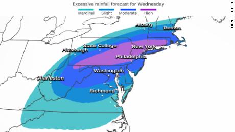
The Weather Prediction Center has placed a "high risk" for rainfall over parts of the Mid-Atlantic and Northeast
The WPC has issued the highest alert level (4 out of 4) for excessive rainfall from southern and eastern Pennsylvania into Connecticut.
More than 60 million people are under flash flood watches for parts of the central Appalachians, Mid-Atlantic, and into southern New York and southern New England. Rainfall of 3 to 8 inches is expected with isolated higher amounts forecast within the next two days in this area.
Northeast braces for potential flash floods
Areas that normally do not experience flash flooding will flood. Lives and property are in great danger through Thursday morning from the northern Mid-Atlantic to the Northeast.
"Gulf hurricanes often have a 'second card to play' when they reach the Northeast," Miller said.
"The eastern foothills of the Appalachians are vulnerable to flooding because of geography. All the moisture from the Gulf and even the Atlantic are pushed up against the mountains by the circulations around Ida. The mountains enhance the rainfall, then gravity takes over (and) the water flows downhill, which can lead to significant flash flooding," Miller said.
According to the Weather Prediction Center, high-risk days -- such as today -- are less than 4% of the days in a year. However, the high-risk days account for 2 out of 5 flood-related deaths, and 9 out of 10 flood-related damages.
We could see rainfall rates of 1 to 2 inches per hour within the heavy downpours expected, causing rivers to quickly rise and flash flooding in urban areas.
A tornado threat for this same region also will continue for Wednesday.

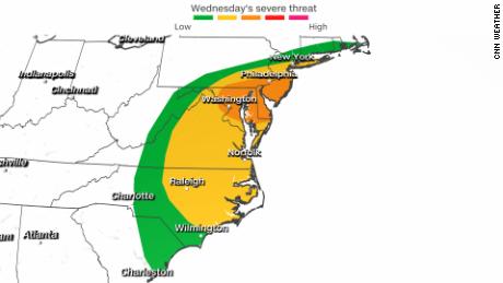
A risk of severe storms from the Mid-Atlantic to Northeast
Several tornadoes and scattered damaging winds are probable across portions of the Mid-Atlantic, mainly during the afternoon and evening hours. A level 3 out of 5 risks for tornadoes covers the Mid-Atlantic, including Philadelphia, Baltimore and Washington, DC.
New York City is in a level 2 of 5.
New York state agencies are bracing for Ida to possibly blanket downstate with half a foot or more of rain in some areas as well and for the threat of an isolated tornado.
Agencies are preparing response assets, New York Gov. Kathy Hochul said Wednesday, with thousands of pieces of equipment ready to deploy and a 24/7 Department of Transportation command center propped up.
"New York City, Long Island, and areas in the Southern Tier, Mid-Hudson Valley and Capital District could see up to six inches of rain, with locally higher amounts, as Ida passes through the area," the release from the governor said.
"There is also the potential for strong thunderstorms with gusty winds through early Thursday, as well as the threat of an isolated tornado, especially for downstate areas," the release said. "Ida is expected to move quickly to the northeast with rainfall ending across eastern portions of the state by late Thursday."
Similarities between Hurricanes Ida and Camille
"There are certainly a lot of similarities with Ida and Camille more than 50 years ago," Miller said.
"Both storms formed in the same spot, hit near the same spot and both have a similar trajectory over the Northeast. Camille's floods in the northeast were deadly."
That storm brought up to 27 inches of rain to portions of the Mid-Atlantic, leading to rising rivers sweeping through Virginia towns.
Camille first hit the US as a dangerous Category 5 hurricane along the central Gulf Coast in August of 1969.
The storm followed a path very similar to Ida through Tennessee, Kentucky and off the Mid-Atlantic coast.
"Flash" - Google News
September 01, 2021 at 10:00PM
https://ift.tt/3mVaGlA
Ida will unleash deadly and damaging flash flooding in Mid-Atlantic and Northeast - CNN
"Flash" - Google News
https://ift.tt/39L7UpV
Shoes Man Tutorial
Pos News Update
Meme Update
Korean Entertainment News
Japan News Update
Bagikan Berita Ini


0 Response to "Ida will unleash deadly and damaging flash flooding in Mid-Atlantic and Northeast - CNN"
Post a Comment